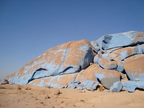
rtwe
 Air terjun ini tampak seperti air terjun dalam dongeng, bukan? Inilah Izvorul Bigar, salah satu air terjun paling indah di Romania sekaligus nomor satu dari delapan air terjun paling unik di dunia. Izvorul Bigar terletak di barat daya perbatasan Romania, tepatnya di Taman Nasional Cheile Nerei-Beusnisa yang menghuni bagian selatan Pegunungan Anina, Caras-Severin County. Air terjun cantik ini dilindungi oleh pemerintah secara resmi sejak tanggal 6 Maret 2000. Area sekitarnya pun ikut dijaga ketat untuk melindungi kelestarian Izvorul Bigar.
Apa keistimewaan Izvorul Bigar sampai disebut sebagai air terjun paling unik di dunia? Pola curahan air Izvorul Bigar memang tidak biasa jika dibandingkan dengan air terjun lainnya. Menyebar dan jatuh dalam tetesan-tetesan kecil serupa hujan gerimis. Air Izvorul Bigar berasal dari sungai musim semi yang bersumber dari gua di atas bukit, kemudian mengalir sampai ke tebing Izvorul Bigar setinggi 8 meter yang ditutupi lapisan lumut hijau sebelum akhirnya jatuh dan bergabung dengan aliran Sungai Minis di bawahnya.
ttr
Photo by Placestoseeinyourlifetime.com
Karena keindahannya yang luar biasa, penduduk setempat sampai menyebut Izvorul Bigar sebagai keajaiban dari Tebing Minis. Selain itu, Izvorul Bigar terletak titik 45 derajat Lintang Utara, tepat di antara Kutub Utara dan Khatulistiwa. Jadi semakin lengkaplah keunikan Izvorul Bigar. 


Dahab - Blue Desert adalah sebutan untuk gurun berwarna biru di Dahab, Mesir. Dinamakan seperti itu karena bebatuan besar di gurunnya memang berwarna biru. Tapi jangan salah, rupanya itu adalah sebuah simbol perdamaian.

Mungkin, tak banyak yang tahu tentang gurun biru ini. Letaknya memang cukup jauh dari Kota Kairo, tapi Anda bakal terkejut dengan pemandangan di depan mata. Suatu gurun yang dipenuhi bebatuan besar berwarna biru!

Dilansir dari situs resmi pariwisata Mesir, Senin (30/9/2013), Blue Desert ini berada di Gurun Sinai, Semananjung Sinai. Dari kota Dahab di kawasan Laut Merah, perjalanan memakan waktu sekitar 2 jam dengan mobil.

Anda bakal dibuat terkesima setibanya di Blue Desert. Betapa tidak, ada pemandangan kontras antara gurun pasir yang berwarna cokelat kekuningan dan batu-batu besar yang berwarna biru. Ini bukan fatamorgana, ini nyata!

Ternyata, warna biru pada bebatuan tersebut adalah hasil karya seorang seniman asal Belgia bernama Jean Verame. Dia mengecat bebatuan di sana menjadi berwarna biru sepanjang 6 km pada tahun 1980. Total, dia menghabiskan 10 ton cat biru dan menghabiskan waktu hingga satu tahun lamanya.

Usut punya usut, Verame rupanya tak sembarang memberikan warna biru pada bebatuan di sana. Rupanya, Verame melakukannya sebagai simbol perdamaian dunia yang didasari oleh perjanjian damai Mesir dan Israel tahun 1979.

Saat itu, Israel bersepakat untuk menarik mundur tentara dari Semenanjung Sinai dan semenanjung tersebut tetap menjadi milik Mesir. Semenanjung inilah yang jadi batas Asia dan Afrika, memiliki destinasi wisata cantik baik gurun atau lautan, serta berlokasi strategis.

Lalu, mengapa warna biru yang dipilih? Verame mengungkapkan, warna biru diambil dari warna langit di atas Semenanjung Sinai. Verame pun sebelumnya meminta izin kepada Presiden Mesir saat itu, Anwar Sadat dan catnya diberikan gratis dari PBB.

Aksi Verame memang patut diapresiasi. Kini, Blue Desert pun menjadi daya tarik turis dunia. Selain memotret keindahannya, biasanya mereka mndirikan tenda dan bermalam di sekitar bebatuan biru di sana.
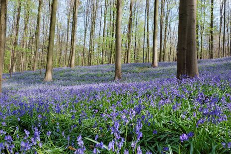


Halle - Jika biasanya pemandangan hutan terlihat hijau, maka berbeda dengan hutan Hallerbos di Halle, Belgia. Saat bulan April hingga Mei, hutan ini bakal berubah warna menjadi biru dan terlihat sangat cantik. Penasaran?

Ada banyak fenomena alam di dunia, salah satunya bisa Anda lihat di Belgia. Di sana terdapat kawasan hutan bernama Hallerbos atau biasa disebut 'Blue Forest' alias hutan biru.

Dilongok dari situs Atlas Obscura, Selasa (7/1/2014) Hallerbos berada di Halle, antara Flanders dan Wallonia. Letaknya tak jauh dari ibukota negara Belgia, Brussels.

Nah, waktu terbaik datang ke Hallerbos adalah pada akhir bulan April hingga Mei. Saat musim semi itulah, hutan ini terlihat berwarna biru!

Bukan dari pohon-pohon yang menjulang tinggi, tapi warna birunya berasal dari bunga bluebell yang bermekaran. Bunga ini bernama latin Hyacinthoides non-scripta dan terdapat di beberapa negara di Eropa, seperti Inggris, Belanda, dan Belgia. Bunga ini tingginya hanya mencapai 10-30 cm saja.

Hallerbos pun disebut-sebut sebagai tempat terbaik melihat bunga bluebell. Ada banyak bunga tersebut di sana dan saat mekar, seketika warna biru menghiasi lanskap hutan Hallerbos. Bagaikan permadani biru yang luas dan laksana negeri dongeng saja.

Kawasan Hallerbos seluas 1.300 hektar pun dapat traveler jelajahi hingga puas. Hampir seluruh sudut kawasan hutan ini ditumbuhi bluebell, banyak traveler yang berjalan-jalan di jalan setapak di dalam hutannya dan berfoto-foto di sana. Perpaduan warna hijau dari pepohonan dan warna biru dari bunga bluebell memang sangat elok dipandang.

Traveler bisa naik kendaraan pribadi, mobil untuk datang ke Hallerbos. Siap-siap bulan April mendatang, Hallerbos alias hutan biru ini bakal membuat Anda jatuh cinta! 


Danau Retba di Senegal, Afrika Barat.
Danau Retba di Senegal, Afrika Barat.(daily mail)
 Dari udara, perairan itu tampak seperti kolam susu stroberi. Merah muda. Persis seperti paduan cairan susu dan sirup stroberi. Dengan penampakan seperti ini, banyak orang menyebutnya sebagai danau pink. 
Dikutip dari Daily Mail, nama sebenarnya adalah Danau Retba, berlokasi di Senegal, Afrika Barat. 
Mengapa airnya bisa berwarna pink? Berdasar sejumlah penelitian, warna air danau itu terkait dengan tingginya kandungan garam. Tak seperti penampakannya yang terkesan manis, kandungan garam di perairan itu mencapai 40 persen.
Menurut Michael Danson, seorang ahli bakteri extremophile dari Bath University, kondisi itu menjadi area berkembangbiaknya organisme penyuka garam bernama Dunaliella salina.
"Warna pink dihasilkan Dunaliella salina. Organisme ini menghasilkan pigmen merah yang dapat menyerap dan menggunakan energi sinar matahari untuk menciptakan energi tambahan sehingga mengubah warna air jadi pink,” katanya. 
Banyak penduduk sekitar yang memanfaatkan karakteristik danau itu sebagai sumber mata pencaharian. Mereka bekerja mengumpulkan garam dan mineral yang terkandung dalam air danau. Tak heran jika terlihat tumpukan garam menggunung di tepian danau. 
Dengan keunikan yang tersaji, danau ini juga menjadi magnet bagi wisatawan untuk rekreasi. Seperti pemandangan di Laut Mati, banyak pengunjung yang menguji tingkat kepekatan garam dengan mengapung di danau. Tingginya kadar garam membuat mereka tak mungkin tenggelam di danau sedalam tiga meter itu.

 Permandangan yang menakjubkan pabila Padi bercahaya Pink di Malam hari di Jepun. Biasa kita lihat titik-titik cahaya bintang di langit, tapi ini pula bintang-bintang pink menyinari di Sawah padi dimana Sawah padi ini dipasangkan 20,000 LED merah jambu dan memecahkan rekor dunia.


Sawah padi Shiroyone Senmaida di Jepun kini muncul dalam Guinness Book of World Records dan telah didaftarkan sebagai Globally Important Agricultural Heritage Systems (GIAHS) tahun lepas, sebagai tapak yang unik dan bernilai.

Saksikan lagi gambar-gambar panorama memukau pemandangan di bawah ini..


Terletak di Semenanjung Noto, yang kaya dengan kepelbagaian dengan iklim yang agak panas, sawah padi terkapar atas cerun curam berlatar belakangkan Laut Jepun. Dibentangkan seperti mozek, ia mengandungi lebih 2,000 kolam bekalan air untuk pertanian.


The annual Senmaida (thousand rice fields) Light Up (Senmaida Aze no Mantoue 千 枚田あぜの万燈), Pada Okt 8 2011. Ini adalah salah satu Ritual pencahayaan Ishikawa yang paling popular dan acara penutup musim perayaan Noto. Senmaida, koleksi 2000 sawah padi ditanam oleh penduduk tempatan yang berminat dalam penanaman padi mereka sendiri, akan dinyalakan dengan ribuan lilin. Sawah padi ditanam di lereng bukit di pantai Laut Jepun hanya di luar bandar Wajima. Ini adalah salah satu pemandangan paling indah di Ishikawa.


Cano Cristales - Colombia
Sungai ini namanya Cano Cristales, terletak di Kolombia. Sungai ini memiliki 5 warna diairnya. Dikenal juga dengan "Sungai Lima Warna" atau "Sungai Pelangi." Nah, yang bisa bikin airnya jadi berwarna itu adalah ganggang khusus yang ada pada bebatuan disungai tersebut.

Arus air sungai mengatur jumlah matahari yang bisa mencapai ganggang, dan selama musim hujan, arus tersebut menjauhkan sinar matahari dari dasar sungai. Pada musim kemarau, airnya terlalu dangkal jadi tidak akan mengeluarkan warna-warna tersebut. Tapi saat-saat diantara kedua musim tersebut merupakan waktu yang tepat bagi Cano Cristales untuk memamerkan warnanya.

Selama waktu-waktu tersebut, dasar sungai ditutupi oleh berbagai warna, mulai dari biru, hingga hijau dan merah, dengan banyak gradasi warna. Sayangnya keindahan ini hanya bertahan beberapa hari, antara musim hujan dan musim kemarau. Tapi hal itu yang justru membuat sungai ini menjadi lebih spesial.

Sayangnya, atau mungkin untungnya, sungai ini terletak didaerah yang terpencil, didekat kota La Macarena. Sungai dengan lebar 20 meter dan panjang 100 meter inihanya bisa dicapai dengan menggunakan kuda atau bagal dan hanya sedikit agen perjalanan yang menawarkan perjalanan kesana.


MH370 search and rescue, helicopter and ship

Share This article

Updated @ 07:20 April 7: It has now been almost exactly a month since flight MH370 went missing. We still haven’t found any debris, but over the last couple of days we have heard some “pings” that might be from the black boxes aboard the missing plane. On Sunday, Chinese media outlets reported that its Haixun 01 patrol ship heard pings for around 90 seconds. Then, on Monday morning, Australia reported that Ocean Shield — a huge ship that’s towing a pinger locator — had detected an underwater pinger twice: first for 2 hours and 20 minutes, and then later for 13 minutes. In all three cases, the pings were on the 37.5kHz frequency used by airplane black boxes (the flight data recorder, FDR, and the cockpit voice recorder, CVR). To read more about black box pingers, read our story about airplane tracking technology (or the lack of it).
The search area continues to move north, which means the weather conditions are now actually quite favorable for finding debris from flight MH370. Unfortunately, though, the pings detected by the Chinese ship came from “four and a half kilometers” (2.8 miles) straight down — and suffice it to say, performing a salvage/recovery mission some 15,000 feet underwater is rather difficult.
Map showing the possible MH370 black box ping locations
Map showing the possible MH370 black box ping locations [Image credit: The Guardian]
Updated @ 06:30 April 1: We’re now three weeks into the search for Malaysian Airlines flight 370. Satellites and aircraft continue to spot objects in the Indian Ocean, but in the few cases where we’ve got our hands on those objects, none of it has belonged to MH370. Other than that, there’s one other odd tidbit: Malaysian authorities have released the full transcript of MH370′s air traffic control communications. The most pertinent point seems to be that the pilot’s final words were not “all right, good night” — they were actually a much more normal-sounding “good night Malaysian three seven zero.”It is not clear how Malaysia got the wording so wrong. It’s hard to believe that the government would try to intentionally misdirect us, but that’s what it looks like. Once this whole situation is resolved, I’m sure there will be a big investigation into how the Malaysian government bungled this whole thing, and how to prevent such atrocious mismanagement from occurring in the future.
Malaysia Airlines flight 370, full transcript
Malaysia Airlines flight 370, full air traffic control transcript [Image credit: Mark Stone]
Updated @ 11:10 March 27: Thailand’s Thaicote satellite has spotted another 300 objects in the Indian Ocean, about 200 kilometers (120 miles) south of the objects spotted by the French satellite. This new imagery was captured on March 24, one day after the French data. Earlier today, the 11 search-and-rescue aircraft were called off after just a couple of hours due to bad weather and zero visibility. We still haven’t physically located any of the objects spotted by satellites — and due to bad weather and strong currents, it may be some time until we finally track down the debris of flight MH370.
300 new objects, spotted by the Thaichote satellite
The MH370 search area, on March 27 [Image credit: BBC]
Updated @ 10:45 March 26: 122 objects, possibly debris from flight MH370, have been identified in new satellite imagery captured by the French company Airbus Defence and Space. The objects are up to 23 meters (75 feet) in length, and are spread out over an area of 400 square kilometers. Australian search-and-rescue planes today checked the areas highlighted by the satellite imagery, but left without finding anything. There is still no sign of oil slicks or floating debris that would help pinpoint the wreckage of flight MH370. As you can see in the image below, we’re searching tens of thousands of square kilometers for signs of debris — using just seven military and five civilian planes, and a few ships (but they cover a very small area, very slowly).Suffice it to say, I would not be surprised if we never find the remains of flight MH370.
The 122 new bits of possible MH370 debris
The original story, about how we tracked flight 370 to its crash landing in the Indian Ocean, continues below.
Yesterday morning, the Malaysian prime minister confirmed that Malaysia Airlines flight 370 crashed in the south Indian Ocean, killing all 239 people on board. Curiously, though, despite the PM’s confidence, this conclusion is based entirely on second-hand information provided by UK satellite company Inmarsat. There is still no sign of debris from MH370, and investigators still have absolutely no idea what happened after the final “All right, good night” message from the cockpit. If you’ve been following the news, you probably have two questions: How did Inmarsat narrow down MH370′s location from two very broad swaths across central Asia and the Indian Ocean, and furthermore, if we know where the plane crashed into the ocean, why haven’t we found it yet?

How Inmarsat tracked down flight MH370

After flight MH370′s communication systems were disabled (it’s still believed that they were disabled manually by the pilots, but we don’t know why), the only contact made by the plane was a series of pings to Inmarsat 4-F1, a communications satellite that orbits about 22,000 miles above the Indian Ocean.
The initial Inmarsat report, which placed MH370 along two possible arcs, was based on a fairly rudimentary analysis of ping latency. Inmarsat 4-F1 sits almost perfectly stationary above the equator, at 64 degrees east longitude. By calculating the latency of MH370′s hourly satellite pings, Inmarsat could work out how far away the plane was from the satellite — but it couldn’t say whether the plane went north or south.
Inmarsat, flight MH370 satellite communications radius
A map showing the location of Inmarsat 4-F1, which received Satcom pings from MH370, and the plane’s radius from the satellite (calculated from the “ping” round-trip time).
Inmarsat's global coverage
Inmarsat’s global coverage. The satellite that tracked flight MH370 is shown in purple.
To work out which direction was taken by flight MH370, Inmarsat, working with the UK’s Air Accidents Investigation Branch (AAIB), says it used some clever analysis of the Doppler effect. The Doppler effect describes the change in frequency (the Doppler shift) as a sound/light/radio source travels towards the listener, and then again as it moves away. The most common example is the change in frequency of a police or fire truck siren as it passes you. Radio waves, such as the pings transmitted by flight MH370, are also subject to the Doppler effect.
Basically, Inmarsat 4-F1′s longitude wobbles slightly during its orbit. This wobble, if you know what you’re looking for, creates enough variation in the Doppler shift that objects moving and north and south have slightly different frequencies. (If it didn’t wobble, the Doppler shift would be identical for both routes.) Inmarsat says that it looked at the satellite pings of other flights that have taken similar paths, and confirmed that the Doppler shift measurements for MH370′s pings show an “extraordinary matching” for the southern projected arc over the Indian Ocean. ”By yesterday [we] were able to definitively say that the plane had undoubtedly taken the southern route,” said Inmarsat’s Chris McLaughlin.
MH370, Australian satellite imagery of possible plane debris
A satellite spotted some possible debris off the coast of Australia — but by the time airplanes arrived to check out the scene, the debris had gone.

So, where is flight MH370?

At this point, if we assume that Inmarsat knows what it’s doing, we know with some certainty that flight MH370′s last satellite ping originated from around 2,500 kilometers (1,500 miles) off the west coast of Australia. Because we know how much fuel the Boeing 777 was carrying, we know that it probably ran out of fuel sometime after that last ping, crashing into the Indian Ocean. Assuming the plane was flying at around 450 knots (517 mph, 833 kph), the potential crash zone is huge.
The southern Indian Ocean is one of the most inhospitable and remote places on Earth. Its distance from major air and navy bases make it one of the worst possible places to carry out a search and rescue mission. Even if satellite imagery purports to show debris from flight 370, waves, weather, and ocean currents mean that the debris will be constantly moving. ”We’re not searching for a needle in a haystack,” said Mark Binskin, vice chief of the Australian Defence Force. “We’re still trying to define where the haystack is.”
Multiple nations are sending search-and-rescue aircraft and ships to the region to look for flight 370, and the US is deploying its Towed Pinger Locator — a device that can locate black boxes up to a depth of 20,000 feet (6,100 meters). The flight data recorder (FDR) or cockpit voice recorder (CVR) generally only have enough battery power to ping for a month or two, so time is of the essence.

What happened to flight MH370?

An airplane blackbox -- they're not actually black, incidentallySo, the million dollar question remains: What series of events led to Malaysia Airlines flight 370 ending up in the Indian Ocean?
There appear to be two likely options. The most pertinent point still seems to be that the plane’s ACARS (automated reporting system) was manually disabled. This would indicate that the plane was either hijacked, or that the ACARS had to be disabled for some other reason (a fire). It’s possible that there was some kind of disaster on-board, killing or disabling everyone, and the plane continued on auto-pilot until it ran out of fuel. It’s also possible that the plane was hijacked (perhaps by a passenger or one of the pilots), and they continued to fly the plane on some kind of suicide mission.
Neither of these explanations quite ring true, but really, given the dearth of information, it’s the best that we can do. At this point though, we should be terrified of another eventuality: Given where the plane crashed, we may never find the flight data recorder (FDR) or cockpit voice recorder (CVR) — theorizing about the fate of flight 370 might be all we can ever do.


Here are the benefits of soursop leaves can be used as a traditional medicine to treat various diseases and other health disorders .treating CancerSoursop leaves is said to possess the power of 100 cycles of chemotherapy to fight cancer . Way, take 10 pieces of old soursop leaves which boiled in 3 cups water until the remaining 1 cup , drink 2 times daily for 2 weeks . Soursop leaves can be used as a chemotherapy even more berkasiat because only kill cells that grow abnormally and let the cells grow normally .Asthma Drugs and Shortness of BreathPrepare 7 made ​​of soursop leaf nest by ants rang -rang . Then squeeze and water capacity up to approximately half a glass . Drink every morning until your illness cured .treating BoilsTake some young soursop leaves as much as 5 to 10 pieces then put in places exposed to the boil boil until dry.Cough Medicine LightFor mild cough , have 7 young soursop leaves . Squeeze water and capacity . Drink every morning before any manyantap .Treating Back PainSoursop leaves can also be used to cure back pain . The trick provide 20 sheets of soursop leaf and then boiled with 5 cups water use down to 3 cups and drink 1 time sehar 3/4 cup .Treating Eczema and RheumatismCrushed some soursop leaves until smooth and place or paste on the affected part to not feel pain anymore , usually must be made up to a few days .

About this blog

Diberdayakan oleh Blogger.

Popular Posts

Pengikut

Welcome text

Flag Counter

Blogger news

Blogroll

Blogger templates